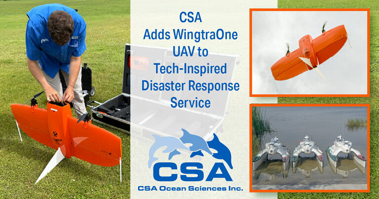
CSA Ocean Sciences Inc. (CSA), a global marine environmental consulting firm, today unveiled its latest investment in uncrewed technology – a WingtraOne GEN II unmanned aerial vehicle (UAV) – as part of the company’s natural disaster response and recovery service. CSA’s state-of-the-art UAV will now join forces with a fleet of uncrewed surface vehicles (USVs) of varying form and factor, to offer unmatched capabilities in the rapid damage assessment of event-impacted areas and infrastructure, whether situated inland, on the coast, or offshore.
“In the critical hours following hurricanes, floods, and other natural disasters, rapid situational awareness is essential,” said Chris Echols, CSA’s Vice President of Commercial Operations and Geomatics Lead. “By deploying autonomous craft rather than personnel in potentially hazardous environments, we can safely and efficiently deliver precise images and data from above, on, and below the water that allow response teams to prioritise the most appropriate action plan. Our latest acquisition, the WingtraOne GEN II UAV, brings a new dynamic to our time-sensitive surveying capabilities, delivering high-resolution aerial maps, 3D models, and orthomosaics with ultra-precise accuracy – as tight as 1 cm with Post-Processed Kinematic (PKK).”
Thanks to the UAV’s vertical take-off and landing (VTOL) functionality, the WingtraOne GEN II can launch from restricted or debris-covered environments and survey up to 310 hectares (766 acres) in a single 49-minute flight – over 10 times faster than traditional methods. With robust weather tolerance (IP54-rated, 27 mph sustained wind capability), it can operate effectively in the immediate aftermath of a major weather event. The platform also supports payloads including red-green-blue (RGB), light detection and ranging (LIDAR), and multispectral sensors for diverse assessment needs.
CSA’s UAV will work in tandem with the firm’s fleet of USVs, a range of autonomous maritime platforms built by SeaRobotics and equipped with interchangeable sensor suites to suit the mission at hand. Available in 1.8m, 4.0m, 5.7m, and 11.0m models, each USV is primed to execute remote hydrographic mapping in areas unsafe for crewed boats. Each vessel supports advanced sonar and imaging tools that detect submerged debris, assess channel navigability, and support environmental recovery efforts.
“Our mission is simple: to deliver clarity, speed, and safety when it matters most,” added Mr Echols. “By integrating surface and subsurface data, CSA is now able to deliver an
unparalleled understanding of the post-disaster landscape, enhancing decision-making for emergency managers, FEMA units, insurers, and infrastructure providers, all while keeping personnel out of harm’s way in often dangerous and unpredictable environments.
“All CSA’s disaster response technologies are engineered to minimise risk to personnel while accelerating the delivery of actionable insights,” said Mr Echols. “Whether scanning rooftops for insurance assessments, identifying structural collapse, or guaranteeing safe maritime navigation, CSA’s disaster response service is designed to optimise survey time, streamline overheads, and increase operational confidence.”
CSA is currently working with several state governmental emergency management teams, FEMA, and commercial interests, including utility companies and insurance adjusters, to prepare disaster response plans in expectation of ‘Above-Normal’ cyclone activity in the Atlantic Basin during August through October. CSA’s Crisis Management team also provides a year-round, 24-hour emergency hotline exclusively to clients and partners, allowing impacted parties to register an incident, triggering CSA responders to immediately assess response requirements and action mobilisation plans.
You can read more of the latest from the world of Marine here.